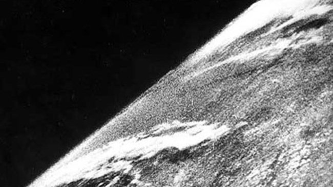
Were you alive before we saw Earth from space? If so, you were born on or before October 24, 1946. That was when a group of soldiers and scientists in the New Mexico desert launched a V-2 rocket – carrying a 35-mm motion picture camera – to a height 65 miles (105 km) above Earth’s surface. NASA defines the edge of space as 50 miles (80 km) above the surface. After a few minutes, the camera dropped back to Earth and was destroyed on impact. But the film survived.

The 1st photo of Earth from space shows a look at the clouds from above. The image is from October 24, 1946. Image via White Sands Missile Range/ Applied Physics Laboratory/ Wikimedia Commons.
Reliving the momentous day
Air & Space magazine tells the story of this major event in space history:
Snapping a new frame every second and a half, the rocket-borne camera climbed straight up, then fell back to Earth minutes later, slamming into the ground at 500 feet per second. The camera itself was smashed, but the film, protected in a steel cassette, was unharmed.
Fred Rulli was a 19-year-old enlisted man assigned to the recovery team that drove into the desert to retrieve film from those early V-2 shots. When the scientists found the cassette in good shape, he recalls, “They were ecstatic, they were jumping up and down like kids.” Later, back at the launch site, “when they first projected [the photos] onto the screen, the scientists just went nuts.”
Before 1946, the highest pictures ever taken of the Earth’s surface were from the Explorer II balloon, which had ascended 13.7 miles in 1935, high enough to discern the curvature of the Earth. The V-2 cameras reached more than five times that altitude, where they clearly showed the planet set against the blackness of space. When the movie frames were stitched together, Clyde Holliday, the engineer who developed the camera, wrote in National Geographic in 1950, the V-2 photos showed for the first time “how our Earth would look to visitors from another planet coming in on a space ship.”
Another early image from space

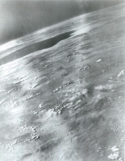
Scientists quickly got better at taking Earth’s picture. Here’s a still frame from about 6 months later, taken from V-2 #21, launched on March 7, 1947. This picture is from 101 miles (162 km) up. The dark area on Earth at upper left is the Gulf of California. Image via White Sands Missile Range/ Naval Research Laboratory/ Wikimedia Commons.
Why do trees shed their leaves.mp4
0 seconds of 35 secondsVolume 0%
See a panorama of Earth from 1948 here
See videos and read the rest of the story from Air & Space.
Bottom line: On October 24, 1946, a movie camera on board a V-2 rocket captured the first photo of Earth from outer space.
Enjoying EarthSky so far? Sign up for our free daily newsletter today!
Eleanor Imster
View Articles
About the Author:
Eleanor Imster has helped write and edit EarthSky since 1995. She was an integral part of the award-winning EarthSky radio series almost since it began until it ended in 2013. She and her husband live in Tennessee, where they enjoy guitar playing and singing. They have 2 grown sons.


